APPROACH CONTROLLER (STUDENT 3)
Position overview
As the name implies, Approach is responsible that aircraft when they approach the airport. For arriving aircraft, the hand over point is normally when the aircraft enters the STAR (Standard Instrument Arrival) entry point. Approach is responsible that separation is made in a safe way. In case the STAR doesn't end at the initial approach fix (final), Approach is responsible for vectoring aircraft on to the final with proper altitude and speed. Approach may also vector aircraft away from a STAR or SID (Standard Instrument Departure) if this is necessary for safety reasons, or to get a good traffic flow.
Normally Approach also handles departure's responsibilities, taking care of departing aircraft which are handed over to Center Control. Arriving aircraft are usually handed over to Tower when they have established ILS (Instrument Landing System) or when on final for visual approach.
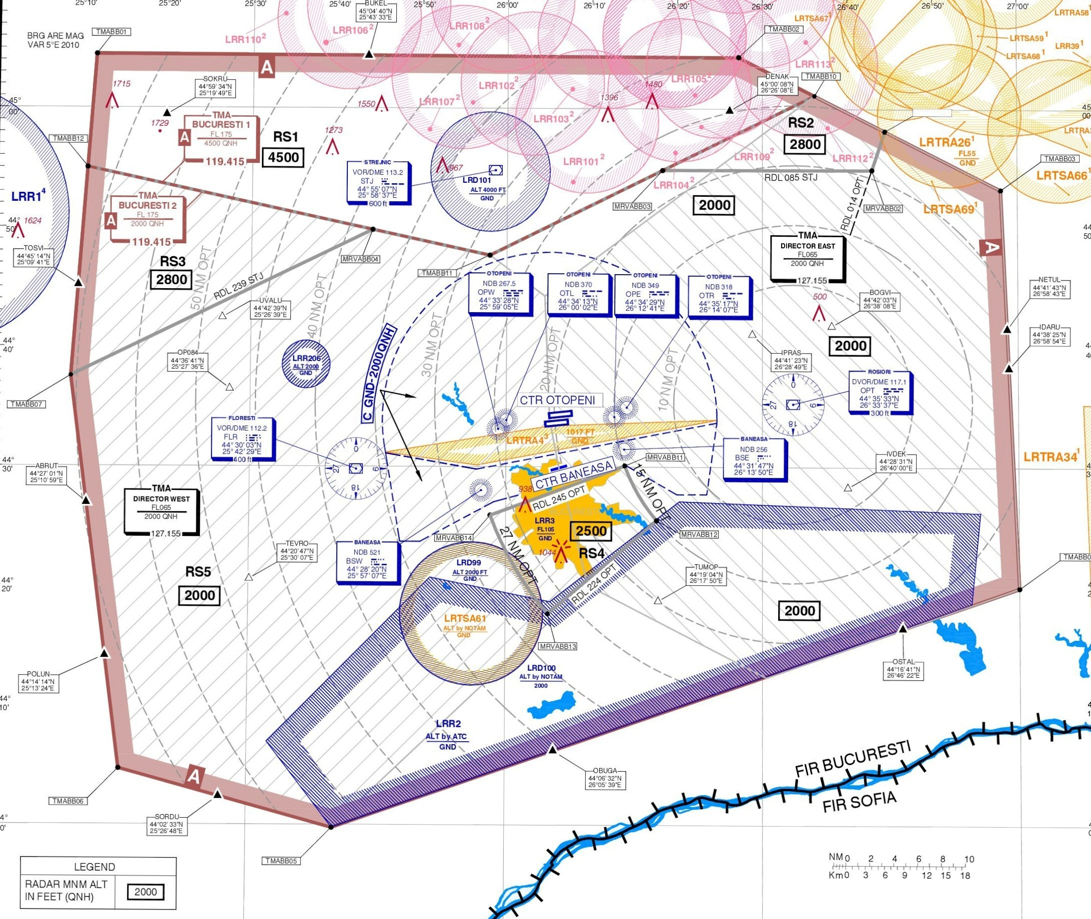
Bucharest Approach have under control TMA Bucuresti airspace which is classified as class A airspace where only IFR flights and SVFR are permitted. The vertical limits on TMA Bucuresti are 2000ft-FL175 with mention that in north of TMA vertical limits are between 4500ft and FL175 because of higher elevation and other activities in that area. Below this limits is class G uncontrolled airspace excluding CTRs which are under tower control. In airspace you have to control all IFR flights with are departing or arriving at Otopeni and Baneasa and also flights with just cross the airspace at an altitude between 2000ft/4500ft and FL175. Your main objective as approach controller is to maintain the separation between aircraft and to ensure them a safe departure, arrival on crossing of the airspace and then we can talk about efficiency and economy of the airlines. In all TMAs from Romania the horizontal separation is 5nm and vertical separation 1000ft. You have to find the potential conflicts from time and to avoid them before is already too late. The transition altitude is 4000ft and the transition level is set by ATC but generally is FL050. Also when the local QNH is greater than 1013 hPa you should avoid to descending aircraft to FL50 because vertical separation between an aircraft at FL050 on standard QNH (1013hPa) and an aircraft at 4000ft on local QNH is less than 1000ft.
Bucharest Approach uses the Callsign LROP_APP and transmits on frequency 118.250. It's full radio Callsign is “Bucharest Approach”. When the main frequency is serviceable it will be used alternative position with Callsign LROP_A_APP transmitting on frequency 120.600 with the same radio Callsign: “Bucharest Approach”.
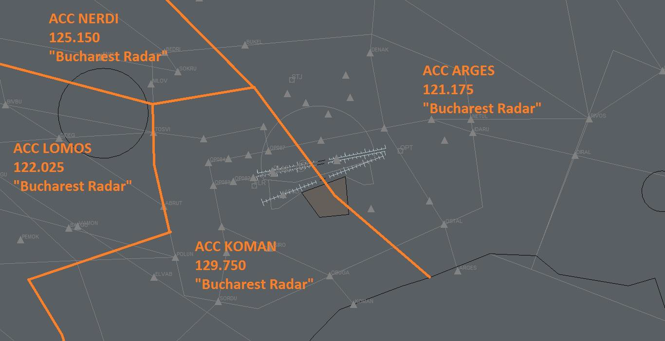
You have to handoff aircraft to the tower position when aircraft are establishing on ILS or if is on visual approach when they have runway in sight. You also have to know that coordination with tower is mandatory. You should coordinate with tower twice for each aircraft. First time when an aircraft is entry your airspace mentioning the Callsign of aircraft, arrival runway and if it is possible estimate time until final. The second coordination should be when aircraft is established on ILS or for visual when they have runway in sight, so exactly before handoff to tower position, mentioning that aircraft is on final. The handoff to radar position should be done until aircraft leave your airspace on horizontal or vertically. You have to know which radar position you should handoff the aircraft. In real life in low traffic situation sectors NERDI, LOMOS and KOMAN are working like one sector only named KONEL which use the frequency of LOMOS 122.025 and sector ARGES and DINSI are also working like one sectors which use frequency of ARGES 121.175. So then you have one sector for aircrafts witch leave your airspace to west and other sectors for aircrafts witch leave your sector to east. On VATSIM in most of the time is only one radar position which cover all radar sectors in Romania and that is LOMOS on 122.025. You also can coordinate anytime with a radar position for any aircraft using the voice/text communication but also electronic coordination using tools from Euroscope.
When you log in into Bucharest Approach you should coordinate with Tower position (if is online) to know the active runways and also to select them in Euroscope. The main runways which should be use at Otopeni are 08L and 08R with are equipped with CAT III ILS approach in case of LVO and also ensure a short taxi route for departing the aircraft and a short approach for aircraft with comes from west (the most of them). So when the wind is calm and also even if is light wind favorable for runway 26L/R (till 6-7kt) you have to use runways 08L/R as active. So in most of the time, in normal conditions, when active runways are 08L/R the both runways are used for arrivals and departures. When active runways are 26L/R is recommended to use runway 26R for departures and runway 26L for arrivals. The active runways can be dependent on local restriction which can be found in NOTAM.
In most of the time conventional SIDs and STARs are suspended so only RNAV procedures in use. If one aircraft is not able for RNAV he will receive vectors. So if active runway is 08 will be used U arrivals/K departures and if runway 26 is active will be used X/R arrivals/M departures.
Because this is a radar position all your actions should be focused on tag of the aircraft. You have to assume aircraft when they are on your frequency and you have control of them. So when you receive the handoff pop-up for an aircraft you have to assume the tag only after the pilot contacts you. If an aircraft was just handoff to you and he is not crossing your airspace and should be with other controller you have to refuse the tag immediately and if is necessary to tell to the controller to which position should handoff the aircraft. In images below you have all necessary explanations for ROMATSA tags.
TAG Information
The pink tag mean that aircraft is not in your airspace but will be soon.
This pink tag with white callsign mean that you recive an handoff from other contoller.
The yellow tag mean that aircraft is assumed by you and you have full control for him.
The yellow tag with pink callsign mean that you initiate a handoff to next contoller.

The grey tag mean that aircraft is not in your airspace and also he will never cross you airspace.
The grey tag with squawk code instead of callsign mean that the tag in uncorelated.

The grey line without tag mean that tha aircraft have transponder on standby but is recived by a primary radar.
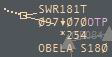
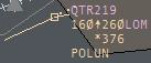
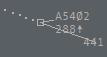
This is the ROMATSA tag's structure:
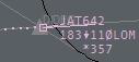
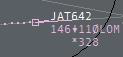
CALLSIGN
CURENT ALTITUDE - VERTICAL SPEED INDICATOR (UP/DOWN) - CLEARED ALTITUDE
- HANDOFF POSITION/POSITION WITCH HAVE TAG ASSUMED
SECTOR EXIT ALTITUDE (USED FOR COORDONATION) - ASTERIX - GROUND SPEED
CLEARED HEADING/DIRECT - CLEARED SPEED
Now we describe the operational mode of ROMATSA tags. When you use left-click on CALLSIGN you open the handoff pop-up menu and right-click will show you the drawn route for aircraft. Using left-click on CURENT ALTITUDE or VERTICAL SPEED INDICATOR and CLEARED ALTITUDE, if appear, you open the cleared altitude menu. Using right-click on CURENT ALTITUDE will show you drawn route with expecting altitude and handoff positions. If the next controller position is not correct you can change it using left-click on position indicator. If you use left-click on SECTOR EXIT ALTITUDE, you will open COPX altitude menu where you can coordinate level changes with other positions. ASTERIX is operable only on right-click and will open a text box where you can put a way point for direct or any remarks. If you use left-click on CLEARED HEADING, you can set assigned heading and if you press right-click you can write a way point for direct. Using left-click on CLEARED SPEED you can set assigned speed restriction in IAS and using right-click you will set assigned speed in mach.
Besides using the tag, you also have to work with “Sector exit list” and “Sector inbound list”. These are very useful tools in Euroscope for operable radar positions. In Sector inbound list you can see aircraft which will cross your airspace. The aircraft are ordered by estimate time to entry in your airspace. In “Sector inbound list” you can see for each aircraft the Callsign, the position which control the aircraft, entry point end estimate time and flight level and also the exit way point and estimate time. From that list you can send electronic coordination for entry points and entry flight level. In “Sector exit list” you can see aircraft which are under your control which are ordered by cleared flight level to see if you have two aircraft or more at the same altitude and prevent a conflict easier. In that list you can see for each aircraft the Callsign, the cleared flight level, exit point and estimate time, COPX flight level and for aircraft landing in your airspace you have to select the runway and star (if necessary) for arrival.
Duties
We take a flight from airbone to handoff to ACC position and backward.
We supose DLH1CF is flying from Bucharest Henri Coanda to Munich:
Pilot: Bucharest Approach, good evening, DLH1CF airbone runway 08R, passing 2500ft.
ATC: DLH1CF, good day, Bucharest Approach, radar identiefied, continue SOKRU1K departure, climb FL280.
Pilot: SOKRU1K, climb FL280 DLH1CF.
Note: The upper extract is only an example. From initial contact to handoff to Bucharest Radar you can give anytime radar vectors using heading or direct to, to change cleared altitude or to give speed restrictions. You have to do this to ensure a quickly crossover of your airspace for aircraft, but in the same time to ensure a safety departure or arriving avoiding conflicts between aircraft. In next extract you have used phraseology for radar vectors, altitude change and speed change:
- DLH1CF, turn left heading 290.
- DLH1CF, proceed direct SOKRU/turn left direct SOKRU/cleared direct SOKRU.
- DLH1CF, climb FL360/stop climb at FL070/continue climb FL280.
- DLH1CF, reduce speed 220kt or less/maintain speed 240kt/no speed restrictions/free speed.
If in a transmission to pilot you have to give more than one of this according to vectors, altitude and speed clearance you have to respect this order: HAS (heading, altitude, speed). Example: DLH1CF, direct to SOKRU, climb FL360, no speed restrictions.
Because for aircraft this is first contact with a radar position you have to check if squawk is set corrected and if tag is correlated and set to right aircraft and after that to say “radar identified”.
Also tower will coordinate with you and will tell you he has an aircraft which will depart from one runway. You have to respond to him and to clear the takeoff. If traffic is not permitting this, you tell to tower instructions after departure for departing aircraft or if the traffic is not permitting at all you tell to tower to wait with takeoff clearance.
You also have to know transition altitude. For example, transition altitude at Otopeni is 4000ft, when you climb and aircraft to 4000ft is on altitude and he must be on local QNH but if you want to climb him above he will be on level and will set QNH on STD mode. You don't have to announce this to them, as they already should know this.
ATC: DLH1CF, contact Bucharest Radar 122.025, have a nice flight, good bye!
Pilot: Bucharest Radar on 122.025, good bye, DLH1CF.
Note: You have to handoff the aircraft to Bucharest Radar before reaching FL175 and to ensure some time to contact radar until aircraft reach FL175. The best moment to handoff the aircraft to radar is when this pass FL150, but this depend by aircraft performance.
We supose ROT3VR is flying from Barcelona to Bucharest Henri Coanda:
Pilot: Bucharest Approach, good evening,ROT3VR inbound TOSVI decending FL110.
ATC: ROT3VR, good day, Bucharest Approach, radar contact, follow TOSVI2U arrival for ILS approach runway 08R, decend FL070.
Pilot: TOSVI2U arrival for ILS 08R, decend FL070.
Note: This is first contact with the aircraft. You have to check if aircraft is correlated and appear on radar and to confirm that saying “radar contact”. Then you have to give the instruction to the aircraft in the following order: HAS (heading, altitude, speed) and also the arrival runway and type of approach. If you give to aircraft a STAR, you tell him arrival runway and approach type just after STAR name and then continue with altitude to descend and speed restriction if is needed. If you give radar vectors to aircraft tell him “radar vectors for...approach type and runway” at the end of instruction HAS.
Example:
- Follow STAR arrival for approach type and runway, descend x, maintain speed x. - for STAR.
- Fly heading x, descend x, maintain speed x, radar vectors for approach type and runway - for vectors
Also here you have to coordination with tower: “Tower, ROT3VR entry at TOSVI for ILS08R in about ten minutes on final”
ATC: ROT3VR, direct OBELA, decend 4000ft, qnh 1028.
Pilot: Direct to OBELA, decend 4000ft, qnh 1028.
Note: From initial contact to handoff to Otopeni Tower you can give anytime radar vectors using heading or direct to, to change cleared altitude or to give speed restrictions. You have to ensure a quickly crossing of your airspace by aircraft but also to avoid conflicts between aircraft. If you want to create a quickly route for aircraft using direct to... and if the aircraft is on STAR, you have to direct him to points which are on STAR route only. If aircraft is on vectors you can direct him to any point in your airspace but also you can use headings. In next extract you have used phraseology for radar vectors, altitude change and speed change:
- ROT3VR, turn right heading 110.
- ROT3VR, proceed direct OBELA/turn right direct OBELA/cleared direct OBELA.
- ROT3VR, turn right/left by 5 degrees.
- ROT3VR, descend FL060/stop descend at FL080/continue descend 4000ft.
- ROT3VR, reduce speed 220kt or less/maintain speed 240kt/no speed restrictions/free speed.
If airport is closed or is too busy you can put aircraft in holding. The best way for that is to use standard holding points which you can find on STAR charts. example: DLH1CF, hold over UVALU.
If is a standard holding point is not mandatory to say the side of holding, but if you give another way point for holding you have to mention this. example: DLH1CF hold over TUTIX on left side. You also can mention more information for pilot like: altitude for hold, time to hold, etc.
You also have to know transition level. For example, if transition level is FL050, when you descend and aircraft to FL050 is on level but if you want to descend him below you have to say feet and also to give local QNH to aircraft. If the local QNH is greater than 1013 you have to avoid descending aircraft to FL050 because between an aircraft at 4000ft (on local QNH) and an aircraft at FL050(on standard QNH) is less than 1000ft and this means that vertical separation is not ensured.
Also you have to coordinate with tower and to tell him for each aircraft the type of approach and the runway you give it and also the time until he is on final. Also you can coordinate again with the tower before handoff and to announce him the aircraft is on final and again the runway. In this mode tower and ground control know how to manage their traffic.
You can announce pilot which order number they have for landing.
Example:
ROT3VR you are number two for ILS approach 08R / you are number two for landing. That helps you because pilots know how to adjust speed to approach and that help to separation between aircraft.
ATC: ROT3VR, decend 2500ft, clear for ILS approach runway 08R.
Pilot: 2500ft, clear ILS 08R.
Note: The most used type of approach at Otopeni is ILS. The altitude to intercept ILS is 2500ft but if the traffic needs can be also 3000ft. To intercept localizer correctly you have to bring aircraft to FAP (Final Approach Point - Ex: OBELA for 08R) at an angle of 30 degrees by runway axe. For example, if an aircraft is coming from North-West for ILS runway 08R he has to come to OBELA on heading 110. It is not a problem if this component varies a bit.
If aircraft request visual approach vectors you have to vector him to the runway on axe of the runway and ask him to report when have runway in sight and then to handoff him to tower. Also for ILS approach you can ask pilot to report localizer establish or full establish on ILS that means also localizer and glide slope intercepted. After the aircraft is establish on ILS you have to coordinate with tower: “Tower, ROT3VR is established on ILS 08R”
ATC: ROT3VR, contact Otopeni Tower 120.900, good bye!
Pilot: Otopeni Tower 120.900, good bye!
Note: The moment of handoff to tower should be when aircraft is establishing on ILS or if is a visual approach when he has runway in sight. As phraseology you can tell to aircraft “radar services terminated” because next position is not a radar one, but this is not mandatory.
Efficient Arrival/Departure within TMA
In these images you have some efficient tips for efficient arrivals in TMA Bucharest for LROP for runway 08 and 26 in use:
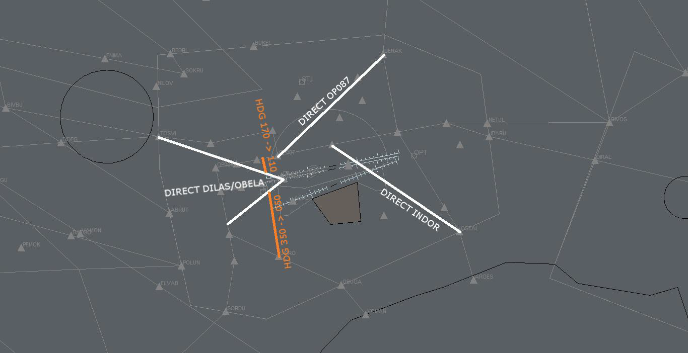
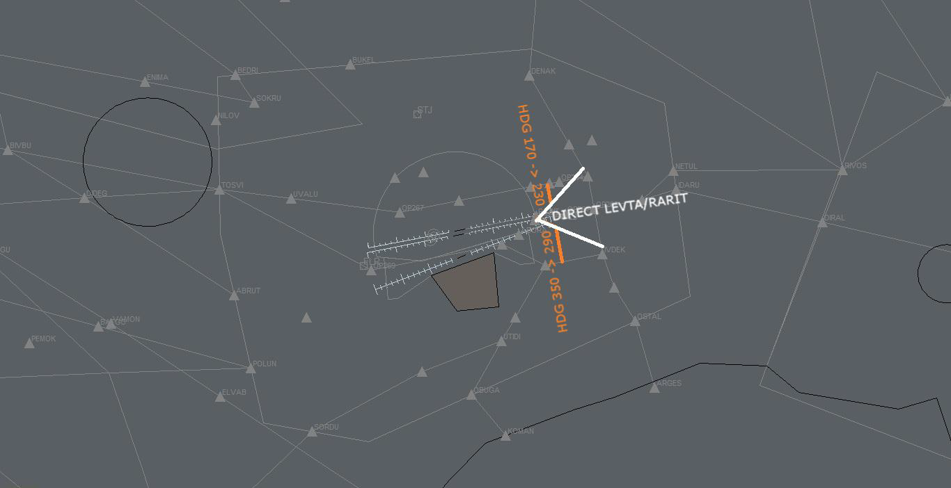
These arriving tips can be used after aircraft follow the STAR until the shortcut point.
For departure aircrafts, with exception of POLUN1K departure where you have to wait until aircraft reach FL105, you can proceed them direct to TMA exit point just after departure.
These efficient arrivals and departure will be used only when traffic is permitting.
Procedural Approach
Procedural approach services are used at airports which because of radar equipment availed are not able to provide a safe radar vectors service. In Romania procedural approach serviced are in use at Bacau(LRBC), Baia Mare(LRBM), Craiova(LRCV), Iasi (LRIA), Oradea(LROD), Sate Mare(LRSM), Sibiu(LRSB), Suceava(LRSV), Targu Mures(LRTM) and Tulcea(LRTC). At these airports all services, from ground to approach, are provided by the tower position which used only a frequency. You will receive the arriving traffic from radar position inbound the CTR entry point and descending to minimum airway altitude specified on the airport charts. Then you have to give to the aircraft the arrival approach procedure and also a STAR if is available and to descend him to minimum approach altitude. When aircraft is on arrival procedure you can ask him any time about position, altitude, speed and so on, information which can help you separating aircrafts. After the aircraft report on final (ILS establish/runway in sight) you can provide regular tower and ground services. For departing aircraft, ground and tower services are regular and after departure you have to climb aircraft to minimum airway altitude which aircraft is following after leaving your airspace and to let him to follow the SID. If is not any SID available, you have to give him runway heading after departure and then when he passes over a safe altitude you can proceed him direct to the exit waypoint. To know his altitude, you have to ask him or to give instruction like “report passing 2000ft”. Also when he reports approaching minimum airway altitude you can handoff him to the radar position. The problem with procedural approach is because of safety you can't have two arrival/departing aircrafts at the same time in the airspace. So for arrival aircrafts the second aircraft will hold at the entry point and for departing aircraft, the takeoff clearance to the second aircraft should be given after first aircraft is handover to radar position. If you have a VFR traffic which cross your airspace when you have a departing or arriving traffic you have to keep him at an altitude below that IFR aircraft is descending to intercept localizer and also to keep runway axes cleared of the VFR.
In the next paragraph you have examples for a procedural approach arrival or departure from Bacau (LRBC) airport:
We supose BMS231 is departing from Bacau to London-Luton:
Pilot: Bacau Tower, good day, BMS231 on stand 3 at Bacau request IFR clearence to Luton.
ATC: BMS231, good day, Bacau Tower, you are cleared to London-Luton, via INBID departure, climb initial FL60, sq 5431.
Pilot: Cleared to Luton, INBID vectors departure, climb initial FL060, sq5431.
ATC: Readback is corect.
Pilot: BMS231, we are ready for push and start.
ATC: BMS231, you are clear for push and start, qnh 1017.
Pilot: push and start approved, BMS231.
Pilot: Ready for taxi, BMS231.
ATC: BMS231, taxi holding point C, rwy34 via C.
Pilot: Via taxiway C to holding point runway 34.
ATC: BMS231, backtrack runway 34 Pilot: Backtrack 34, BMS231.
ATC: BMS231, wind is 330 with 4kt, you are cleared for takeoff runway 34, mentain runway heading.
Pilot: cleared for takeoff rwy 34, on runway heading, BMS231
Pilot: BMS231, airbone ATC: BMS231, roger, continue on runway heading, report passing 3000ft.
Pilot: continue on runway heading, will report 3000ft, BMS231.
Pilot: passing 3000ft, BMS231.
ATC: BMS231, roger, turn left direct INBID, climb FL120, report pasing FL100.
Pilot: BMS231, direct INBID, climb 120, report 100.
Pilot: BMS231 is pasing FL100.
ATC: BMS231, now contact Bucharest Radar on 127.900, good bye!
Pilot: 127.900, bye!
We supose BMS234 is arriving at Bacau from Liverpool:
Pilot: Bacau Tower, good day, BMS234 decending to FL100 approaching BUCSA.
ATC: BMS234, good day, Bacau Tower, follow BUCSA4A arrival for ILS approach runway 34, decend at 2600ft by qnh 1024, report ILS extabilish.
Pilot: BUCSA4A for ILS runway 34, decend 2600ft by qnh1024, will report on ILS, BMS234.
Pilot: BMS234, on ILS runway 34.
ATC: BMS234, wind is 320 with 6kt, you are cleared to land runway 34, vacate on taxiway C.
Pilot: wind copied, clear to land runway 34, we vacate on C, BMS234.
Pilot: BMS234, runway 34 vacated on taxiway C.
ATC: BMS234, roger that, welcome to Bacau, taxi to stand number 3 via C.
Pilot: Via C to stand 3, BMS234.
| Date | Changes |
|---|---|
| 13.03.2016 | Initial release |